Mount Frankland
Mount Frankland National Park
Directions - From the centre of Walpole, head north on North Walpole Road all the way to Mount Frankland Road. Take a turn here and follow the signs all the way to the car park. The trail starts from the new information structure.
The Hike - Mount Frankland is a place that I love returning to, with a great combination of stunning scenery, amazing views, and incredible flora. I first visited during a family holiday in 2016, and over the years since then, I've cherished every return journey to one of the highest points around the Walpole Wilderness. Part of the enjoyment comes from that magical feeling of being on a holiday in the South West of WA, but there is another element of Mount Frankland just being a great place to wander around.

Returning in the spring of 2023 as part of a three week research trip for my Best Walks of South Coast WA guidebook, this was one of the first walks of what would be a thoroughly enjoyable trip. Although I had hiked this one a few times in the past, I still wanted to reaquiant myself with the trail, and hopefully get some better photos. Last time I was here to shoot the trail for the website in 2020, it was grey, raining, and not conducive to photographing a trail in the right way. With better weather on this visit, I was keen to explore an old favourite, and enjoy a more relaxing amble around than my previous visit in 2021. That time I was riding through on my Munda Biddi E2E, and after a long climb from Fernhook Falls, a wrong turn, and picking a poor spot to dump my gear for this side quest, I was a bit tired and rushed when I got here. Having the luxury of time on this trip, I exited the car, and was ready to explore the various trails that make up the full Mount Frankland Experience.
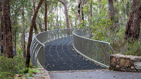
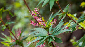
There are technically three trails located here, but it's quite easy to combine them all into one, which makes the most sense if you're planning to visit the summit anyway. Having a look around the impressive information building, I always love reading the various boards that tell you all about the Walpole Wilderness and Mount Frankland. From here I set off towards the Walpole Wilderness Lookout, that is a relatively recent addition to the area. Following the paved path, it didn't take long until I spotted my first wildflowers of the walk, and the splashes of colour would remain for the rest of the hike. This is a botanically rich area, and as you pass through different vegetation types along the trail, you'll see different wildflower species (if you visit during peak time in Spring). Leaving the pavement, you join a stainless steel walkway that curves around the base of the granite hill, allowing you to appreciate the mossy delight of the rockface without damaging the fragile environment.

Keep walking, and you'll reach the pièce de résistance of this part of Mount Frankland, with the Walpole Wilderness Lookout extending out from the hill, providing stunning views looking north towards Mount Mitchell, Mount Roe and Granite Peak. It's a comforting sight to me, looking out over so much green, and knowing that it's a national park purely there to protect the natural environment (even if DBCA continues to practice large scale destructive burning here). Taking a moment to soak it all in from the end of the platform, you never know when you'll be back, so I like to appreciate every visit. Making my way back to the information shelter, the remaining two trails can be found heading off in the opposite direction. Most people will come here and head straight to the summit via the return path, but the real delight for me visiting Mount Frankland is the Caldyanup Trail. Taking you around the base of Mount Frankland, you get to appreciate the size of both the granite dome, and the surrounding Karri Forest.
Before getting to the Caldyanup Trail you follow another paed trail down to an important building for this area, the Old Towerman's Hut. Mount Frankland was once the location of a fire watchman, who's job it was to gaze out over the wilderness all day and report back on any potential bushfires. The old hut along this path is where they would live, and the summit trail recreates their commute to work. You can have a look inside the modest accommodation, complete with fire pit, and it would have been a lonely but peaceful existence out here. From August to November each year I would have loved having this place to myself but I missed my opportunity. Just past the Old Towerman's Hut is the little walk sign that signifies the start of the Caldyanup Trail that takes you around the base of Mount Frankland. Unless you've taken notes at the information shelter, or one your research beforehand, it would be quite easy to miss, but the rewards are plentiful if you know it's there.

Entering the Karri Forest, you completely forget about the signage and stainless steel walkways (for now at least), and enter an overgrown world of mossy rocks, cream coloured trunks, and masses of wildflowers. There are some girthy trees greeting you at the start, showcasing how large the Karri trees can grow, as you snake your way up and down the contours of the hill. Reaching the side of the granite dome, you pop out of the undergrowth and are staring up at the bulk of Mount Frankland, amazed at the moss covered surface extending high above the tree canopy. The first time I saw this I was captivated, and the feeling hasn't diminished over the years, it's a fantastic place to stand and admire the combination of geology and flora. You duck and weave between the edge of the granite and the forest below, both with their unique joys, rounding the southern edge of the hill where you get some awe-inspiring views looking up at the bulk of Mount Frankland. Popping in and out of the vegetation, you eventually reach an open section that is my favourite spot along the whole route. With views looking east across the national park, hidden in the forests below is the Frankland River winding its way all the way to the coast.
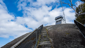
With rolling hills and big skies, it's a good spot to stop and pause, so you can take in the majesty of this place. There were a lot of new wildflowers here, which continued as I crossed the metal bridge over some exposed granite, a relatively recent upgrade from the old wooden bridge that I really loved. Joining up with the paved path that takes you up to the summit, this is the beginning of the 100m vertical climb leading to the top of Mount Frankland. A combination of pavement, concrete steps, and a solid metal ladder, it's a fun ascent that during spring always produces a variety of new wildflowers that you won't see along the lower slopes. The final push sees you walk along a metal fence to stop people rolling off the side of the hill, with the old watchtower in view (that has been converted into a solar powered comms tower). From the summit, you get 360 degree views over the Walpole Wilderness, all the way to the coastline, that you can trace towards Denmark and Albany on a clear day. Exploring the granite summit, there's plenty to see, and I love looking out and seeing nothing but wilderness. When you're finished, head back down the way you came, and follow the paved path all the way back to the car park.

Final Thoughts - Mount Frankland is one of those places in Western Australia that never loses its appeal. It's easy enough for the casual walker but offers something extra for those that want a more natural connection.
Add in the stunning views, quality facilities and signage, and world class nature, if you don't add Mount Frankland to your Walpole holiday itinerary then you're really missing out.
Get out there and experience it!
Be sure to tag any Mount Frankland photos on Instagram with #thelifeofpy and if you enjoyed this hike then feel free to share this page on Facebook with your friends.
If you've found this page or the website helpful and you want to show your support then consider making a small donation by visiting our Ko-fi page. You can give as little as a dollar with no sign-up required and everything will be put towards the website, creating new content and promoting the trail community.


