

Wiilman Bilya Trail
Wellington National Park
Start - Coalfields Highway
Trail Type - Hike
Length - 20.0km (One Way)
Elevation - 452m
Time - 5-7 Hours
Date Hiked - 22nd June 2019
Directions - The northern trail head is located just off Coalfields Hwy. Look for the gravel road on the right hand side about 7km past the Wellington Dam Rd turnoff. Turn right again, drive through the gates and park in front of the Wiilman Bilya Sign.
The Hike - The creation of a new hiking trail in Western Australia is rarer than spotting a numbat in the wild with by our recollections on the podcast episode about this hike, the last Parks and Wildlife built trail being Eagle View sometime in the 90s (the excellent Wadjemup Bidi on Rottnest was mostly grant/sponsorship driven). With such a long wait, Donovan and Alissa from The Long Way's Better and myself were excited to check out the new trail, located a short distance from Collie in the stunning Wellington National Park. While the trail was officially launched in January 2019, we thought we'd wait until at least winter to experience in the right hiking weather and to maybe have a chance at early season wildflowers or winter fungi. At 20km one way it was either going to be an overnighter to take advantage of the brand new campsite or we would organise a car swap and do it in one day.


With both myself and Donovan having limited time and wanting to preserve some of our weekend for other activities we decided a car swap would be best with the initial plan being that once we got to Wellington Dam Rd, Donovan and Alissa would drive my car to the Kiosk end and I would drive their car to the Coalfields Hwy end. Starting at opposite ends we would meet in the middle somewhere and swap keys so we could drive our own cars back home. When it came time to do the hike though Alissa was still battling a cold so decided that a full day of hiking in the predicted stormy weather probably wasn't the best idea (rightly so). Donovan and I then decided to walk it together with a car at each end, which actually worked out well as one thing we didn't think about was both Donovan and Alissa don't have manual licenses so wouldn't have legally been able to drive my car (we would have figured out a system though). As I mentioned the weather was predicted to be rough with afternoon storms set to dump upwards of 60-70mm but I was confident that we would miss most of that if we finished in the mid afternoon. Setting off on the two hour drive to Wellington National Park we left Donovan's car at the Kiosk car park and drove my car out to the start point. Finding the new Wiilman Bilya Trail sign where it said it would be, we were bemused when it showed the location of the actual trail start to be on the other side of the drainage channel that I'm assuming in late winter and spring is full of water.
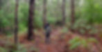
We tried locating a path to the highway but in the end crossed the channel and made a few comments about the interesting choice not to link the car park with the start by a more obvious path. We figured they expect you to walk back along the gravel road you came in on and then hike along the highway over the channel until you reach the start. We eventually reached the other side of the channel and found the trail, which we had to backtrack on so we could begin at the intended start point. Finally reaching the official start right next to the highway we found nothing but a sign stating no motorbikes but were excited based off the short section we had just walked through. Immediately off the highway you enter a world of great Jarrah, lush ferns, green moss and plentiful fungi. Having experienced how nice the Jarrah forests of Wellington National Park can be while on the Sika Trail and Jabitj Trail, I was very excited for a long one way trail that explored the edges of the dam. With access to such a large water source and being in a fairly wet area to start with, the Jarrah forest around these areas can thrive and I believe it is the best in the state (it's a tight race between Collie and Dwellingup).


For those that listen to the podcast or follow The Long Way's Better know of the running joke that Donovan is not the biggest fan of the Jarrah forests, whereas I see it in a more favourable light. Expecting something similar, if not better, than the Sika Trail, I wasn't surprised as we walked along the vehicle track next to the dam and it was just kilometre after kilometre of stunning Jarrah. While following a vehicle track is usually something I don't like, in this case it made sense because it provided a good mix of dam views along with having the beautiful forest on your right. I've said before that vehicle tracks in Karri forest are sometimes better as you get a better sense of scale to the forest and this mature Jarrah was exactly the same. As we twisted around the track different views would open up with more of the dam showing, across to more lovely forest and the sounds of black cockatoos in the distance. Donovan was a convert at this stage and was beginning to really enjoy his Jarrah forest experience, having been wary of the "World Class" label that DBCA had put on this hike in their release documentation. About 2.5km in from the start we arrived at the purpose built for this trail, Nyingarn Campsite (meaning echidna).
Donovan and I had a laugh because as many of you may know, I've yet to see an echidna in Western Australia despite thousands of kilometres hiked over the years and with the drizzly weather I wasn't expecting to see one here (but you never know). The first thing we came across was the toilet block, which we originally thought was the shelter but as we approached it, it became clearer that this was only the beginning. Wonderfully constructed and thought out, the campsite is really high quality and both Donovan and I more than once said that we would love to stay the night here. Perhaps when they finish the proposed Collie Loop Trail that will link up this trail with the town and form a loop with the Bibbulmun Track spur. The shelter are not exactly what you'd expect from a typical Bibbulmun Track shelter and more like the group campsites. There is no sleeping platform, instead just offering up two walls and a roof to keep you a bit dry. There are four bench seats for you to enjoy and the whole thing looks out over the artificial lake created by the dam (I'm going to start calling it a lake from here on out).


There is a picnic table in the open with similar views and steps down to the edge of the lake. We spent a lot of time here marvelling at the location and Donovan even favourably compared it to the Echo Point Campsite on the Overland Track, high praise and a sign I think he was really enjoying the hike. We explored the tent sites up the hill and found them to be well thought out and well designed. A large fallen tree covered in moss provides a natural divider and the whole place just had a magic about it, as if it had existed for a hundred years or so. Thoroughly impressed with the campsite and all the work that has gone into creating a nice place to stay, we said our farewells and moved on into the forest keen to explore what had started out as a fantastic trail. I hung back a little after we departed camp as I was loving all the fungi and moss growing everywhere so was busy taking as many photos as I could (finished the day with over 1200 on the memory card). The quality of the forest here kept its great standard, perhaps even got better as we moved onto single path.
Still traversing the edge of the lake there were moments where it was all clear and you could get wider views over the water and then times when you headed inland a bit to enjoy the tall trees and green ferns. As with any mature forest there was a nice variety of plant life ranging from Bracken Ferns to Banksias to Jarrah to Marri and all kinds of plants that will reveal themselves in the spring as the wildflower season begins. We saw a nice beach just off the trail so we found a clearing and decided to check it out first hand. As we exited the forest and the views widened it was another moment where you could fully appreciate the enormity of the Jarrah forest surrounding the lake created by Wellington Dam. As far as the eye could see were hills of Jarrah forest with the moody skies providing the perfect backdrop. We noted the red colours in the forest on the opposite bank and thought nothing of it, something that in hindsight was very important for the day.


Rejoining the trail we continued on, coming across a fantastic old log that was now blanketed in an assortment of different moss, fungi and lichen. This truly was a treat and something I love seeing in the wetter forests of Western Australia. The run along the water on the Warren River Loop Trail is full of these mossy, decaying features and they are a delight to photograph. I stayed here a while shooting the moss log from various angles before catching back up to Donovan. The now you see it, now you don't approach of the trail with regards to the lake continued here with great effect as the scenery is always changing. Saying goodbye to the lake for a while we headed back into the forest where the lush undergrowth and assortment of different plants and fungi had us raving about this trail.
We were both really enjoying our time here, constantly stopping for photos of the greenery or a new style of undergrowth. I think at one point near the creek crossing Donovan exclaimed something along the lines of having to eat a large helping of humble pie after doubting the World Class claims that had been put on this trail. If the first 5km or so were like this then I was going to need that second battery in my pack for all the photos I was going to take. The photos do convey a little of what it was like but you're missing the whole sensory experience of the wet smells, the touch of water drops falling off the canopy, the close feel of a mature forest and the 360 degree sight line that comes with being out there. It felt like being out on the Donnelly River to Pemberton section of the Bibbulmun Track, just without the golden Karri trunks filling up the forest.
Then we rounded a corner and saw it...


On our side of the intersecting 4x4 track it was all green and on the other side a scene of total devastation. The red tinged forest from before should have been a warning but it looked like it was on the other side of the lake. As it was we had looped around the edges of the lake and were now right in the middle of the aftermath of a recent prescribed burn. I get the reasoning behind prescribed burns and I'm all for them if carried out properly but it hurt so much that the first new trail we get in literal decades and less than six months of it being open they decide that torching it would be a great idea. As you can imagine, Donovan was not a happy camper as listeners to the podcast will know, along with those that read his posts on The Long Way's Better, he absolutely hates walking through burnt forest, more so when it is a prescribed burn. Utterly bemused at the start, we joked around that they knew Donovan was coming so decided to burn here for a laugh. I took some photos of Donovan looking fake cross in front of the charred remains of the forest and we hoped that this would only be a small section of the trail.
We continued on through the blackened mess of what we assume was of very similar quality to what we had just walked through, joking again that it looked like a cool burn as the canopy was left green in places (I severely doubt it was a controlled or cool burn based off what we saw along this section). Remarking that in places they had burnt their brand new trail markers, this was quickly becoming a real downer on what had started off as an excellent experience. Both Donovan and I had been to the Mt Dale area just after the 2015 fires that swept through that area and both enjoy the contrasting colours of the blacks, reds and oranges. The difference there though was that was a natural fire caused by a lightning strike, which is completely normal for the forests of Australia. This type of deliberate mass burning that results in the same destruction, while sometimes necessary, is at least planned so why do it along a recreational trail, especially one that has just been opened and you spent hundreds of thousands of dollars on. Given the option of walking through blackened forest and what we had experienced on the first 5km, my choice would be for the quality mature forest.


We continued on, realising that it wasn't going to end anytime soon. There was a mirage as you dipped up and down the small hills where you would see a bit of green canopy in the distance and think that the end was near but it just kept going and going. At one point we reached an area that had a Two-Face look to it with one side of the trail lovely green forest and the other was the familiar black mess we had been hiking though. What was illogical to me was the side they had burnt was the small strip leading down to the edge of the lake where if a fire ever did break out, access to put it out would be right there compared to the unburnt area where it wouldn't be as easy.
The return to at least half green forest didn't last long and soon we were back in the scorched earth landscape. Luckily the trail goes right on the edge of the lake so you have something nice to look at so we took the opportunity to take some photos of something other than burnt forest. Curious as to when this would end we soldiered on and came across a gully that had been burnt right through. Amazed that they hadn't burnt down the brand new bridge, we deduced that they had taken it out and then replaced it once they'd burnt everything to the ground. It created a surreal scene but based off what we had already been through, it was easy to imagine how nice this little valley would have been. We came across a collection of granite that had been blackened to almost resemble dolerite with what was once green moss just left dry and orange.


You'll notice I'm not writing much here and for good reason, it wasn't terribly enjoyable and went on for over a quarter of the trail. I didn't want to brush over what they've done here so I've included the same amount of photos as I would for a trail that hadn't been burnt. While the photos look striking and the colour palette may look out of the ordinary, this was not nice walking and in points it was very hard to find the trail because there hasn't been a lot of foot traffic and the trail would have been bordered by nice green undergrowth. Passing over logs that were there before, you can see where they had cut steps into them but the prescribed burn has ripped through and put them on weird angles so that would be disappointing for the poor trail builders who put the effort in. There were signs of the fungi fighting through the fire with some Super Mario red mushrooms breaking through on the trail. As we reached what was the end of the burnt section I had had enough. I'm quite tolerant when it comes to burnt forest but at this stage I felt like someone who was claustrophobic stuck in a tight space. I just had to get off the trail and with the trail skirting the edges of the lake I made a decision that this is where we should stop for lunch. Getting out of the burnt forest and into the open of the beach was such a relief.
We found a tree stump to rest our packs on and we shared some rolls I had brought out. Across the lake was the farm that is a feature of the second half of the trail and one we were hoping meant the end of the prescribed burning. With the weather rolling in it was a short stop so we headed back to the trail and continued on for the second half of the trail. Mercifully the burnt forest ended shortly after lunch and we were back into the lush forest we had experienced for the first 5km. I've let my feelings be known on the podcast episode about this trail and have sent an email to DBCA about this issue so I won't harp on about my disappointment. The baffling decision to immediately burn after building a new trail is beyond crazy and the heavy handed approach to the burn means that this section of the trail will be terrible for at least the next few years (and not like the first 5km for at least another 10-20 years). It's hard to understand the thinking when WA has so much natural beauty and tourism has the opportunity to bring numbers to the towns of country WA that are slowly dying away but why would you come if all you see everywhere is burnt forest?


Enough of the burnt forest talk because we had finally reached green forest and it was a sight for sore eyes. I yelled out in joy and Donovan jokingly put his finger to his mouth and made the "shh" sound, something I found too funny not to get him to recreate it for a photo. The difference was night and day as we made our way along the Bracken Fern lined trail, thankful to be in proper forest for the time being. Around lunch we had noticed the darker clouds rolling in and as we walked along it started to sprinkle, creating a new set of issues that would be with us until the finish. While I had a lens cloth and tried to protect my camera from rain as much as possible, it is inevitable that a few spots will get on the lens every now and then (apologies for the later photos). A slightly spotty lens was more than acceptable given we were in lush forest again and we were delighted to come across a couple of dolerite strewn inclines, dark in colour livened up with a bit of deep green moss. The thickets of thin undergrowth trees was very Karri forest like and was a good return to form. Getting dwarfed by the fern lined trail, we were enjoying the last of this type of scenery before the farm fence walking began. We knew based off the map that there would be a bit of 4x4 track that we would walk on next to a farm so it wasn't unexpected when we hit it.
What was unexpected was when we reached the pipeline crossing, there was a "Trail Closed" sign waiting for us on the staircase. Given the size of the thing, we would have seen one at the other end of the burnt section had DBCA in all their infinite wisdom put one on both ends of a one way trail as logic would have dictated. Slightly amused at this blatant stuff-up but not at all surprised, we continued on to begin the farm section of the hike. At this point the heavens opened up a little so I was scrambling to take photos of what I was happy to see wasn't just a typical WA farm where they have cleared everything bar a small single file of trees on the fence line. For whatever reason, there is a farm in the middle of a national park that has been allowed to exist (probably an old land agreement from way back) and luckily the owners have left patches of Jarrah forest so it almost blends in to the rest of the landscape. Following the 4x4 track around the old fence, this isn't necessarily a bad section of the track as the forest opens up and you can get some wider views of the tall Jarrah trees.


With the rain now falling in sufficient quantity that I had no choice but to get out my rain jacket and pack cover, I stopped for a little while and tried to take as many photos as possible of the rolling hills in front of us. Luckily it didn't get that heavy and we were able to walk along with relatively dry cameras, bringing them out every now and then for a few photos. The farm section also marks the hilliest point of the whole trail with a fairly sizeable downhill portion that can be quite slippery on the loamy mud surface of the 4x4 track. Donovan asked me to go ahead for a photo opportunity and I was sure this would be the moment my adhesion levels dropped and I fell on my butt. In the end I was a good model and did the job that was asked. At the bottom of the hill we found a covering of non-native flowers that were quite photogenic even though they weren't natural and the No Entry sign had hilariously been turned upside down by a local Larkin. Continuing along the 4x4 track as it made a series of 90 degree turns and followed the fence line, we arrived at the pipeline once again, a feature of a few walks in Wellington National Park. The pipeline was interesting to photograph but luckily you don't follow it for too long as it wouldn't have made for a very interesting walk. Instead we made another couple of turns and were walking up a hill next to the working bit of the farm where open paddocks contained grazing sheep. Here we could see all the way down to the lake and to the spot where we had decided to take lunch.
While I do enjoy a bit of farm walking to break up a day on the Bibbulmun, this stretch was over 3km of walking the fence line on a 4x4 track and with an abundance of quality unburnt forest right off trail, you have to think that the reasoning behind following this track was due to expedience and possibly a lack of funding. It's a shame really as the variety is nice but it dragged on for a little too long. With one final hill alongside the farm we finished this section and were happy to be pointed back into the forest, albeit on more 4x4 tracks. This wasn't so bad because at least we were in the forest again and it didn't end up lasting too long. Keeping us amused was the middle of the track that had now been converted into a stream as the rains continued. Leaving the 4x4 track and entering a single track section we spotted a giant puddle near a crossing up ahead that if we continued along the track we were following, we would have passed straight through (thank you trail designers for skipping past this bit). Continuing along the single track we entered a lovely stretch that was reminiscent of the starting 5km. A narrow trail through a varied undergrowth with Jarrah as far as the eye could see. Making this section more enjoyable was the large population of grass trees in various shapes and sizes with some quite large examples.


This was shaping up to be a really nice finish after a lot of walking through burnt forest and along fence lines. A cool highlight here was a giant fallen log with a slimy looking fungi growing out of the side. It also marked the start of a very misty section of Jarrah forest that we guessed had been burnt in the last few years. At first I thought it was just drizzle fighting its way through the canopy but on closer inspection it was a fine mist. I love a misty forest in the morning so was great to see the effect so late in the day. In a sign of what was probably in store for the burnt section in a few years, the Soapbush along here was starting to spring up. A fast growing plant, Soapbush can quickly take over an area at a rapid pace, covering up a trail to the point of not being able to see it. Having battled it along my section of the Bibbulmun Track around the Murray Campsite all I can say is I hope they have people willing to maintain this trail otherwise it might be overgrown very quickly. While the Soapbush was still at a manageable height it created a green oasis among the blackened trees, some that seemed to be much older than the typical regrowth Jarrah you find along the Darling Scarp. I enjoyed this section a lot but it didn't last long as just after another small bridge we joined the Sika Trail as it makes its way past Potters Gorge and to the finishing point near the Kiosk.
Having hiked the Sika Trail in December of 2017 and being very impressed with the quality of the Jarrah forest then, I was not happy to find out they had since burnt this area and it looked nothing like what I had experienced. The trail crosses Tom Jones Rd and squeezes in between the road and the pipeline. Previously I struggled to see the pipeline but with the blackened ground devoid of much undergrowth it was quite easy to see. With the rain falling a little harder, my lens cloth soaked through and the camera fogging up quite a bit, photos were becoming more and more difficult to take. Given the burnt state of the forest leading to the Kiosk I wasn't really fussed about taking more shots of burnt Jarrah so only took them when absolutely necessary. One of these occasions was when we spotted one of the old Bibbulmun Track markers with the red waugyl (indicating the Sika Trail side trail). This was a pretty cool piece of history from when the track used to come through Wellington National Park so I'm happy it hasn't been taken down. After rounding the contours of the landscape for the final stretch we reached the car park and located the out of the way Wiilman Bilya sign that was also at the starting point. Very soggy and having mixed feelings about our recent experience we loaded in Donovan's X-Trail and drove back out to my car.


Final Thoughts - The two words that come to mind for this trail are "Potential" and "Disappointment". While it is great to finally see some money being invested in new trails in WA, to see it spoiled by such a large burn within months of it opening goes to show how we value these trails and the forests they travel through.
Investment in trails is meant to be one piece of an effort to diversify an area away from an old and dominant industry like mining or forestry. To sabotage the efforts of a $300k investment in the area by immediately making a large portion of it burnt (and also closed if you walk in from the Potters Gorge end) is really quite baffling.
If this is the blueprint that they are going to look at to judge success or failure on the investment they are making then I wouldn't be surprised if they decide against expanding trail spending, at least for hiking trails. I really hope the further $10mil they have announced will go a long way to making this area a proper trail destination and from what I've heard, the mountain biking options in the area will be spectacular.
When the new trail was first announced I was really excited as my previous trips to Wellington National Park were nothing but positive with what I regarded as the best Jarrah forest in the state, mainly because it was mature and unburnt. To see both the 5-6km section after the new campsite and the area around Potters Gorge recently burnt it's just not the same anymore.
Yes the forest will recover but there could have been more done to leave the area around the trail as it was because it will take a long time to resemble what it would have looked like before. I've made my feelings quite clear in the podcast and also a little more here so I'll switch to some positives.
The campsite is outstanding and they've done a great job thinking about the placement of the buildings and also the tent sites, which often become an afterthought. Having it feel like it's been there for a much longer time is really well done and I think I'll be planning a trip or two out there in the future.
The Jarrah forest from the highway through to just after the campsite is truly excellent and should have been the baseline for the entire trail. If that quality was all the way through then this would truly be a world class trail so it's a shame to see what has happened.
My recommendation for this trail for the foreseeable future (1-2 years at least) is to park at the highway end, walk in to the campsite and stay there the night. It would be a waste if no one experienced the campsite and this is a great option for those wanting a quick getaway or a family friendly overnight hike.
This is why we can't have nice things in WA.
Be sure to tag any Wiilman Bilya Trail photos with #thelifeofpy and if you enjoyed this hike then feel free to share this page on Facebook with your friends.
If you've found this page or the website helpful and you want to show your support then consider making a small donation by visiting our Ko-fi page. You can give as little as a dollar with no sign-up required and everything will be put towards the website, creating new content and promoting the trail community.