

Baruwei Loop
Nitmiluk National Park
Directions - Located in the southern section of Nitmiluk National Park, from the centre of Katherine head north on Giles Street as it becomes Gorge Road and follow this for 28km. There is only one main road to the Nitmiluk Visitor Centre and it is well signed so you can't miss it. There is plenty of parking but it does fill up during the peak period around July school holidays. The walk starts from outside the Visitor Centre where you will find a large information board detailing the Southern Walks in Nitmiluk.
The Hike - The southern part of Nitmiluk National Park is where most of the action can be found thanks to a great walking and biking trail network, accommodation, boat tours, helicopter tours, kayak tours and an impressive Visitor Centre equipped with a lovely restaurant. Over the course of our stay in Katherine, I visited here several times to engage in walking activities & boat trips (see further down the page) and really enjoyed my time checking out this part of the world.


Not everyone is The Life of Py though, structuring their holidays around hiking opportunities at a destination, trying to cram as much as they can into a short amount of time. Sometimes what is required is a relatively gentle loop trail that is designed to appeal to everyone, provide access to some spectacular scenery and be far enough away from the main touristy spot that you feel like you've escaped. Enter the feature hike of Nitmiluk National Park, the Baruwei Loop, a 4.8km circuit trail taking you up towards amazing views of the Katherine River before exploring the open lands of the park and heading back through a slot in the landscape. It was a walk I had planned to do as a singular experience one afternoon but time escaped me so what you see here is the combination of photos from my visit to Butterfly Gorge where I took in the Baruwei Loop to start with, before finishing it off on the return leg. Starting at the Visitor Centre, you head along the linking trail between here and the boat ramp to the north.
The pavement winds its way towards the boat ramp and is a means to an end compared to what is ahead. I did spot a few birds playing in the early morning coolness and the sight of some fungi growing on a stump threw me as I never expect to see fungi in the NT. It's a 400 metre dawdle to the boat ramp where the various boat tours, kayak drop offs and Jatbula Trail transfers happen. You can wander down to the edge of the water but beware of crocs as this part of the river is known to occasionally contain some salties. From the grassed area at the boat ramp, there looks to be two options for the next part of the walk but I chose the pavement next to the metal Baruwei Loop sign as it leads up the hill. You soon reach one of the most interesting parts of the walk as you walk through the geological history of Nitmiluk. Comprised of sandstone that is over 1.6 billion years old, dotted into the giant boulders are what seems like pebbles that have been mortared into the rock face.


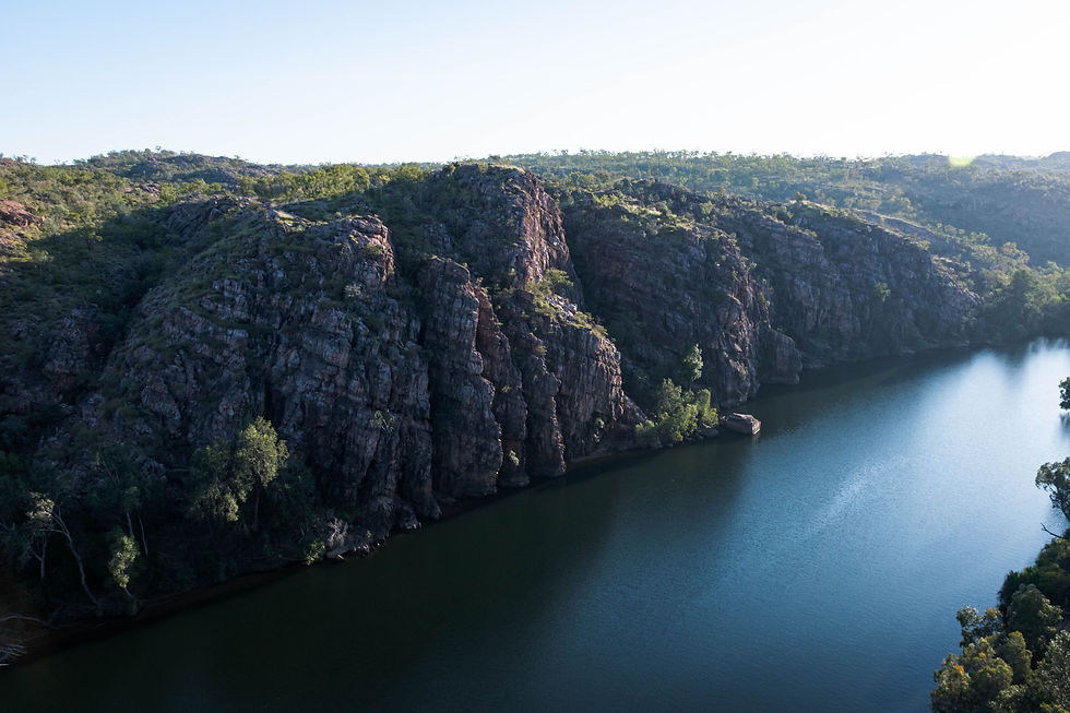
These used to be rocks and pebbles rolling around an ancient river delta and over the years they built up, were compressed under new layers and this is the result. The whole formation is upwards of two kilometres thick in places and it really blows the mind to think of the time scales involved. Climbing up to where you'll get some amazing views is aided by a series of metal staircases and eventually you get glimpses of the gorge and river system below. These glimpses are replaced with full blown vistas as you reach the lower lookout, before making your way up the final staircase to the main Baruwei Lookout. From here the views are breath-taking, as you gaze out over the jagged gorge lining the Katherine River, along with the endless expanse of Nitmiluk National Park to the north. With the still morning air starting to warm up and not a person in sight, this was a real highlight of the whole trip. After taking many photographs, I located the trail as it headed away from the river and set about looping back to the start. Joining up with the mountain bike trails that have been built throughout Nitmiluk, it's a more gentle meander now as you head towards the water tanks on top of the hill that you can see from the Visitor Centre.
For a short section, you walk along the edge of the cliff and get views looking down towards the bustling Visitor Centre, car parks and accommodation spots. The trail winds its way through the trees, passing several rocky platforms that provide a taste of what is found on the longer walks in the park like Butterfly Gorge and Jedda's Rock, plus you might get lucky and spot a Northern Wallaroo. Heading downhill along a wide track, you get some nice views overlooking the eastern side of the park, eventually meeting up with the trail junction for the longer Southern Walks (mentioned above). From here, continue downhill to head back to the Visitor Centre, walking through a slot in the hill where you'll find plenty of mature trees, palms and a bevy of birdlife. The final part of the walk runs parallel to the road and feels a bit exposed as you make your way through the dry grasses. Finish the loop by traversing the area around the car parks before reaching the Visitor Centre for a well earned drink or ice cream.


Katherine River Boat Tour & Kayak Hire - While heading out for a hike is one of the best ways to explore a landscape like Nitmiluk, sometimes it pays to be a tourist and enjoy a different viewpoint. With this being a family holiday, we booked a boat tour on one afternoon and then a half day kayak experience for the more active members of the travelling party for another day. The boat tour is highly recommended with a short trip to the area between First and Second Gorge, where you get off for an exploration and then board a different boat to continue up the river. The guides were fantastic about telling the history of the area, explaining the geology of the gorges and spotting fresh water crocodiles before anyone else. All the tours, boat, kayak and helicopter, are owned and run by the local Jawoyn People and all the money goes back into the community. If you're visiting Katherine, then this is a must do activity.
The kayak hire was an activity that was booked early on in the planning stage as Candy and Hal are keen kayakers. Unfortunately Hal was not with us on the trip so Candy, Caris and myself continued with our booking and spent half a day exploring the gorges carved out by the Katherine River. It was good fun exploring the river as we paddled the area around Second Gorge and then Third Gorge after dragging the kayaks over the rocky area that separates them. Time flew by and unfortunately we picked the wrong side of the river to see the ancient wall art but it was still nice to explore what I think was Lily Ponds Waterfall (dry when we were there). You can do either half day, full day or multi day hire (a group of guys were loaded up for a trip when we were there) and can go as far as you want in the allotted time. We stopped at the end of Third Gorge as it becomes harder and harder during the dry season to drag your kayaks over the sections between each gorge. Again, highly recommended and it provides a different perspective to Nitmiluk.


Final Thoughts – Nitmiluk was a great place to visit and I can see why it's a highly rated national park.
Having a trail like the Baruwei Loop that caters to almost everyone without feeling too touristy is a great addition to the park, especially given there are longer walks for those that want to hike them.
If you're only visiting Nitmiluk to do the boat tours then I recommend putting on the walking shoes as the Baruwei Loop is a great compliment as you get to see the Katherine River from above and below.
Get out there and experience it!
Be sure to tag any Baruwei Loop photos with #thelifeofpy and if you enjoyed this hike then feel free to share this page on Facebook with your friends.
If you've found this page or the website helpful and you want to show your support then consider making a small donation by visiting our Ko-fi page. You can give as little as a dollar with no sign-up required and everything will be put towards the website, creating new content and promoting the trail community.